


Potent storm incoming to New England: Impacts, timing, alerts
An area of low pressure will track to New England’s north Sunday into Sunday night. As it does so, it will drag a strong cold front across the region. A secondary low will form along the front and strengthen as it moves through New England.
ALERTS (as of 1pm Sunday)

Potent storm incoming to New England: Impacts, timing, alerts
TIMING
Initial showers will likely break out across Vermont and western Massachusetts by Sunday late-morning to midday, mainly in western New England. Scattered showers will slide further east through the afternoon, however, a steady rain will not be happening yet. The first half of Sunday is still looking to be dry across most of New England.
Expected weather Sunday early afternoon:

Potent storm incoming to New England: Impacts, timing, alerts
By Sunday evening, rain showers will likely have overspread the entirety of New England. The band of heavy rain will likely begin setting up at this time. Winds will also begin to gradually increase at this time, though they will not be anything of note quite yet. The rain and wind will continue to pick up in intensity as Sunday night goes on. The storm will likely peak early Monday morning for much of New England. Late Sunday is also when rain will likely begin changing to snow at elevation in the Green Mountains.
Potential weather Sunday evening (1st image) and overnight (2nd image):

Potent storm incoming to New England: Impacts, timing, alerts

Potent storm incoming to New England: Impacts, timing, alerts
By around sunrise Monday, rain and snow will continue falling across New England, but the system will begin to slide eastward as the cold front begins sliding through New England. The shield of heavy rain will likely begin to race eastward shortly after sunrise. A quick drying trend will take over from west to east Monday afternoon.
Expected weather Monday around sunrise:

Potent storm incoming to New England: Impacts, timing, alerts
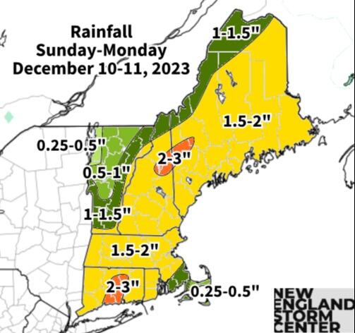
RAIN
This storm will likely feature a shield of heavy rain moving across New England overnight Sunday to Monday. A widespread 1-2 inches of rain will be possible across all of New England, with locally amounts to 3 inches not out of the question, mainly across Connecticut and the White Mountains.

Potent storm incoming to New England: Impacts, timing, alerts
Yesterday, we wrote that there were mixed signals on whether rainfall amounts (and flooding concern) would trend up or down. Over the past 24 hours or so, the trends on rainfall have increased, which is seen by the issuance of flood watches across New England.
Poor drainage flooding will likely be the most common flood issue with this storm. There is a chance for some rivers, particularly in western Massachusetts, Connecticut and into the New Hampshire Wite Mountains and foothills, to reach minor flood stage. Rainfall rates will have the chance to be heavier than they typically get this time of year. Across parts northern New England, snowmelt will also contribute to rivers and streams filling up along with the rainfall.
Flash flooding isn’t a major concern, but it is still possible with the rainfall rates that could be achieved overnight. The Weather Prediction Center upgraded a portion of New England to the second level of flash flood potential. Areas in New England where the ground is frozen will have a harder time getting rid of the water.