


NEW YORK — September 10th marks the peak date of hurricane season, and with Lee and Margot both swirling in the Atlantic, we are right on par.
After being named a tropical storm on Sept. 6, Lee underwent an extremely rapid intensification process and morphed into a monstrous Category 5 hurricane by the following night.

Lee went from having winds of 80 mph to having winds of 160 mph in just 24 hours, joining an infamous group of past hurricanes that have intensified 80 mph or more within a 24-hour period. That list includes Wilma (2005), Felix (2007), Ike (2008), Matthew (2016), Maria (2017), and Eta (2020). All of these storms were devastating, and had their names retired.

Lee is also the eighth Category 5 storm since 2016. Category 5 storms traditionally have been a rarity, however, with ocean water temperatures becoming increasingly warmer in recent years, they are transpiring more often. Record warm sea surface temperatures in the Atlantic this year most certainly have contributed to Lee’s explosive development.
With peak winds of 165 mph as of Friday morning, Lee is the strongest storm of the 2023 Atlantic hurricane season thus far. Though not the strongest ever recorded, Lee can now be included among the strongest hurricanes ever observed in the Atlantic Basin.

Only 29 storms are known to have reached Category 5 status, having maximum sustained winds of 156 mph or greater. The strongest hurricane ever recorded across the Atlantic was Hurricane Allen of 1980. Allen’s peak winds clocked in at 190 mph.

The Saffir-Simpson Scale, which measures hurricane intensity, only has five categories. This comes as a surprise to some, with many people thinking there is a Category 6 or greater. If the trend of stronger storms continues, which is expected, perhaps there will be a Category 6 one day – right now, Category 5 is as powerful as storms get.
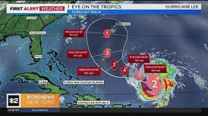
Increasing confidence Lee misses east coast, still brings coastal impacts
As of Sunday, Hurricane Lee has now strengthened back into a Category 3 storm with winds of 120 mph. The forecast models have speeded Lee’s movement up so that by Friday he’s nestled between Bermuda and North Carolina.

Will Lee hit the East Coast? While the verdict is still out on that, some recent model projections are troubling. For the past week, the models have been back and forth with where Lee ultimately winds up.
The final solutions of the two most prominent models, the GFS and European both show Lee not making a landfall in the U.S., but heading to Nova Scotia instead.

However, some of the ensembles, which essentially are blends of many different models do suggest that Lee will be making a landfall along the East Coast, with Long Island and New Jersey being two of the possible locations of landfall. Yes, those are outliers, but definitely cannot be discounted just yet.

We still have time to watch Lee, and it is very likely the models will shift again.
In the very least, high surf, dangerous rip currents, and beach erosion will be observed at our local beaches throughout the upcoming week.

Tropical Storm Margot is expected to strengthen into a hurricane as well next week. Thankfully, Margot poses no threat to land as of now.
Hurricane Lee’s potential impacts in NYC, New Jersey, and more

Jersey Shore:
Some breezy conditions, high surf, dangerous rip currents and beach erosion. Waves 9 to 12 feet.
Long Island:
Similar, with rough surf, dangerous rip currents and breezy conditions. If the track were to be slightly farther west than currently thought, some rain and/or higher wind gusts would be possible on the east end. Right now, that is not the case.
New York City, Hudson Valley, Inland New Jersey and Connecticut:
Nothing but some nice September days if the current forecast holds!