


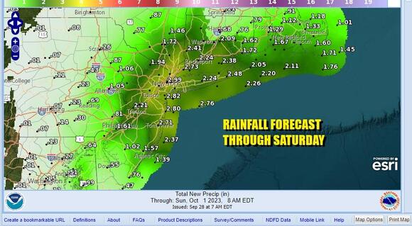
We have the return of gloom & doom. Also we have the risk for a steady, and in some cases, heavy rainfall. Rainfall forecast amounts could exceed 2 inches in some places but where exactly that happens remains a bit of a mystery at this point. As far as the return to gloom & doom, it has already started as the satellite loops indicate, we have higher clouds coming up from the southwest and we can see the lower clouds moving from east to west off the ocean. This puts us in a day where we will continue to see increasing cloud cover.
When we look at the radar at least to start the day, we see rain well offshore and not an issue for now. However with clouds increasing and a northeast wind, temperatures today will not be going far. Most highs will be in the 60s from coast to inland. During the afternoon and evening along the coast at least, we will probably start to see some light rain work its way northwestward and inland.
Tonight we will see more rain move in from off the ocean and back its way northward and westward. How far west the rain gets is an issue and it seems that Eastern Pennsylvania to the Catskills is the northwestern cut off point for the rain. Low pressure developing offshore takes a track to the north and then begins to hook out to the east Thursday night into Saturday morning, and then it will back its way southwestward Saturday afternoon.
Look for some rain overnight and then it is on and off rain Friday and in some places it will be more continuous and on the heavier side. It will be a raw day with a northeast wind thanks to the high to the northeast and the approaching low moving northward offshore. Highs will be in the low to mid 60s at best especially when it is raining.
We expect the rain to linger into early Saturday morning especially along the coast. Once the low begins to move back to the southwest, it will allow high pressure to start building in from the north Saturday afternoon so we could potentially see some improving weather and sky conditions Saturday afternoon. It is a close call though. Highs Saturday will be in the upper 60s and lower 70s.
Sunday we should see genuine improvement as high pressure settles in over Pennsylvania and puts us in a northerly or even northwest flow of air. Sunday should be sunny dry and warm, and it will definitely be the better of the two weekend days. Highs Sunday will be back into the 70s everywhere. Sunday also should mark the beginning of a stretch of dry weather and above normal temperatures and that could last all of next week through Friday. There should be some sunshine each day. Temperatures are going to be on the warm side with highs in the 70s to perhaps even close to 80 in some places beginning Monday and lasting into Wednesday. The surface flow could become more onshore-ish late in the week and that might hold temperatures down a bit but still above average.